Enrich your days with mountain bliss

Active holidays in the Schlern region

Hofer Alpl sits right at the foot of South Tyrol’s most iconic landmark. You simply cannot get any closer to the Schlern.

The Schlern region is often referred to as the heart of South Tyrol. Strictly speaking, it isn't the exact geographical centre—it lies a little bit to the right. But then again, the same is true for the heart in the human body, so we think the description fits perfectly ...

Here, you will find hiking routes, cycling trails, and hut-to-hut treks in every direction. Hike to the summit of the Schlern, visit Prösels Castle, or explore the Hauenstein ruins to experience history and culture in total peace of mind. Because there are so many possibilities, it is always a good idea to take a little more time and stay with us for several nights. This allows you to truly dive into the surroundings and explore all its hidden gems. You are also very welcome to visit us by e-bike – we have a charging station right outside our door.

⇟⇟⇟

Things you need to know

Essential notes

Since you are moving through high-alpine terrain, it is essential to check the weather forecast beforehand – especially for the crossing at the Tierser Alpl! Find all the necessary weather info here. Please note that the tours described below are exclusively summer activities. However, you can also visit us in the winter.

Hikes & Day Tours

⇟⇟⇟

Hofer Alpl – Tuff Alm – Migg’s Cave

Walking time: approx. 1 h 10 min
Total elevation gain: 355 m
Difficulty: easy
Refreshments: Tuff Alm

Are you fascinated by local history and "lost places"? Migg’s Cave is hidden in the rock faces above Ums. It is named after the hermit Franz Mich, known locally as "Migg," who lived there under extremely simple conditions until around 1977. He built a modest dwelling using dry stone walls within a natural rock niche. You can still see various everyday objects, the remains of his walls, and soot stains from his fires. It is a place that gives you a haunting sense of how sparse his life was. There is also a beautiful waterfall nearby to admire.

Route: Reach the cave via a narrow path via the Tuff Alm (Way No. 1, then 8B). Return to Hofer Alpl via forest road No. 8.

MAP

Hofer Alpl – Völser Weiher – Huber Weiher

Walking time: approx. 3 h (including the Huber Weiher loop)
Total elevation gain: 954 m
Difficulty: moderate
Refreshments: Tuff Alm, Völser Weiher Restaurant, Schwimmhütte

In summer, Völser Weiher is a popular swimming lake. In winter, it is perfect for ice skating (skate hire available on-site). While Völser Weiher is often bustling, Huber Weiher is a true hidden gem and much quieter—perfect for a peaceful circular walk.

Route: From Hofer Alpl (1,364 m), enjoy a leisurely downhill walk through dense coniferous forests on Way No. 8. The path is well-maintained and offers views of the Eisack Valley and the Ritten Plateau. Just before the hikers' car park, turn right onto Way No. 2. You will reach Völser Weiher after about 1.5 hours. Huber Weiher is just a 5-10 minute walk above it. Return to Hofer Alpl via the Tuff Alm.

Hofer Alpl – Tschafon

Walking time: approx. 4 h
Total elevation gain: 550 m
Difficulty: moderate
Refreshments: Tschafonhütte

Want to summit the Tschafon without tackling the Hammerwand? It’s possible and a bit more relaxed, but just as beautiful. The tour is physically demanding but not technically difficult

Route: Start at Hofer Alpl and take Way No. 1 towards Teufelsschlucht. At the junction, turn onto Way No. 7 and walk beneath the Hammerwand to the Tschafonhütte (1,737 m), where incredible views of the Rosengarten await. The actual summit (Völsegg Spitze) is just 15 minutes further. Return: Either the same way or take Path No. 4 (later 4A) down to Ums, then follow the "Direttissima" back up to Hofer Alpl (Way No. 3).

Hofer Alpl – Mount Schlern

Walking time: approx. 4 h
Total elevation gain: 1086
Difficulty: very challenging
Refreshments: Sesselschwaige, Schlernhaus

This is the "direct route" for true mountain enthusiasts who want to see the Schlern from its wildest side. The highlight is the journey through the rocky heart of the massif.

Route: Head towards the Schlern walls. Instead of the classic wide path, this route leads into the fascinating Teufelsschlucht (Devil’s Gorge). This is the most spectacular section: you’ll walk over rustic wooden footbridges and narrow paths through the deep, wild-romantic gorge. The rushing water and towering rock walls create a mystical atmosphere—goosebumps guaranteed! Then, climb steeply via the famous Prügelweg (a historic log-paved path) towards Sesselschwaige. The final ascent leads to the vast Schlern plateau and the Schlernhaus (2,457 m)

Note: There is an alternative ascent via the very steep Schäufele-Steig. WARNING: Only use this path for the ascent; using it for the descent is far too dangerous!

Hofer Alpl – Hammerwand and Tschafon peaks

Walking time: approx. 9 h
Total elevation gain: 3,356 m (cumulative)
Difficulty: very challenging
Refreshments: Sesselschwaige, Tschafonhütte

This is the absolute "King’s Tour" of the Schlern massif. It’s not for the faint-hearted (or untrained legs), but it rewards you with some of the most spectacular views in the Dolomites.

You will cross two peaks: the striking rocky ridge of the Hammerwand (2,128 m) and the wooded back of the Tschafon. Warning: The path over the Hammerwand is narrow and exposed in sections!

Route: Head towards Sesselschwaige and climb steeply to the right to the Hammerwand (Way No. 9). From the ridge, walk towards the Tschafon, passing the Völsegg Spitze (1,834 m) for fantastic views of Bozen. Descend to the cosy Tschafonhütte and return via Way No. 7, walking directly under the massive walls of the Hammerwand.

Hofer Alpl – Prösels Castle

Walking time: approx. 3 h 50 min
Total elevation gain: 1,268 m (cumulative)
Difficulty: moderate
Refreshments: Gasthaus Prösler Hof, Castle Bar

Combine hiking with culture! Prösels Castle is one of South Tyrol’s most significant monuments. A guided tour of the chapel, knights' hall, and armoury is well worth it, as are the chilling tales of the historical witch trials held here.

Route: Take Way No. 3 from Hofer Alpl down through shady forests and Alpine meadows to Prösels. The castle is visible from afar, perched imposingly on a rocky outcrop.

Hofer Alpl – Oachner Höfeweg (Farm Trail)

Walking time: approx. 4 h
Total elevation gain: 380 m
Difficulty: easy
Refreshments: Gasthaus Prösler Hof

This trail connects historic farmsteads, manicured vineyards, and chestnut groves

In autumn, several farms offer "Törggelen"—serving new wine, traditional platters, and roasted chestnuts (Keschtn). In warmer months, combine this with a visit to Schloss Prösels. Here you find all information about reservations the opening hours.

Route: Head down towards Prösels (see the "Direttissima" option). At the castle, join the Höfeweg. For the return journey, you can take Bus No. 176 to Ums and walk the final stretch.

Hofer Alpl – Hauenstein Ruin in Seis

Walking time: approx. 6 h 40 min
Total elevation gain: 1,996 m (cumulative)
Difficulty: Moderate
Refreshments: Tuff Alm, Völser Weiher, various options in Seis

This hike leads through legendary forests to two historic sites: the Salegg and Hauenstein ruins. Hauenstein is the more famous of the two, having been the home of the famous medieval poet and knight Oswald von Wolkenstein. Its walls have stood on a massive rock for over 1,000 years. 

Route: Walk down towards Völser Weiher (No. 1) and then follow the shaded woodland paths towards Seis am Schlern (find more details here). You can return to Ums by Bus (Line 176).

Mountain bike & E-Bike tours

⇟⇟⇟

Völs am Schlern – Hofer Alpl – Völser Weiher

Duration: approx. 2 h 30 min
Distance: 14 km
Elevation gain: 580 m
Maximum altitude: 1,446 m

From Bozen to Hofer Alpl

Duration: approx. 7 h
Distance:
 62.3 km
Elevation gain: 
2,090 m
Maximum altitude: 
1,389 m

Val Gardena – Panider Sattel – Völser Weiher – Hofer Alpl

Duration: approx. 6 h
Distance:
 57 km
Elevation gain: 
1,770 m
Maximum altitude: 1,465 m

From Brixen to Hofer Alpl

Duration: approx. 7 h
Distance: 81.5 km
Elevation gain: 1,360 m
Maximum altitude: 1,448 m

Hut-to-Hut Hikes

⇟⇟⇟

Hofer Alpl – Schlernhaus – Tierser Alpl – Grasleitenhütte (Rosengarten)

Walking time: approx. 6 to 7 hours (excluding breaks)

Elevation gain: approx. 1,400 m ascent / 600 m descent
Highest point: approx. 2,440 m
Difficulty: challenging

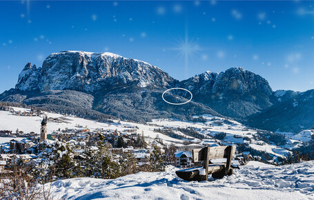
This tour is a demanding mountain trek—a true "King's Stage" into the heart of the Dolomites. Good physical fitness, sure-footedness, and a head for heights are essential. The appeal of this route lies in the dramatic contrast: the striking high plateau of the Schlern on one side, and the jagged spires of the Rosengarten (Catinaccio) on the other.

The three stages at a glance:

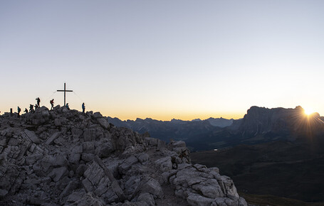
  1. Hofer Alpl ➔ Schlernhaus: From Hofer Alpl (1,364 m), the path leads steadily upwards. This stage covers the most elevation. You will traverse the mountain flanks and ascend via the "Prügelweg" or alternative paths to the wide Schlern plateau. The Schlernhaus (2,457 m), often called the "Castle in the Mountains," offers a phenomenal panorama.

  2. Schlernhaus ➔ Tierser Alpl: A true landscape highlight! You hike across the broad back of the Schlern, with the Rosengarten group always in view. The path dips gently before rising again to the iconic red-roofed Tierser Alpl Hut (2,440 m).

  3. Tierser Alpl ➔ Grasleitenhütte: Behind the Tierser Alpl, you dive deep into the Schlern-Rosengarten Nature Park. Crossing the Molignon Pass (sure-footedness required!) or taking the direct descent through the scree fields, you reach the rustic Grasleitenhütte (2,134 m), nestled between the towering rock walls of the Grasleiten Valley.

Did you know? The Rosengarten (Rose Garden) owes its name to a famous Dolomite legend. Here is the short version:

King of the dwarves, Laurin, owned a magnificent realm within the rocks with a garden full of beautiful, fragrant roses that bloomed year-round. When he fell in love with Princess Similde and kidnapped her, knights pursued him. Laurin tried to hide in his rose garden, but the knights spotted him because the roses moved in the wind.

Furious at being betrayed by his own garden, Laurin placed a curse on it: neither by day nor by night should the human eye ever see the splendour of the roses again.

However, in his rage, Laurin forgot the twilight. That is why the rocks of the Rosengarten still glow today at sunset in the most magnificent shades of red and pink—a phenomenon known as the Alpenglow (or "Enrosadira" in Ladin).

Hofer Alpl – Schlernhaus – Tierser Alpl – Molignon Refuge (Seiser Alm)

Walking time: approx. 6 to 7 hours (excluding breaks)
Elevation gain: approx. 1,300 m ascent / 600 m descent
Highest point: 2,457 m
Difficulty: challenging


This is an ambitious yet breathtaking high-altitude trek. It leads you from the forested slopes beneath the Schlern, across the iconic high plateau, and down to the rolling Alpine meadows of the Seiser Alm, the largest high-altitude Alpine pasture in Europe. The scenery is a perfect blend of rugged Alpine terrain and idyllic meadows. Fitness and sure-footedness are absolute requirements!

Tip: If you take a short detour (approx. 20 min) from the Schlernhaus to the summit of Mount Petz, you will reach 2,563 m—the highest point of the Schlern massif.

Route description:

  1. The hike starts at Hofer Alpl and initially leads steeply upwards through larch forests and over rocky paths (such as the "Prügelweg") onto the Schlern Plateau. This is where you conquer the bulk of the elevation. Once you arrive at the Schlernhaus (the "Castle in the Mountains"), a vast plateau awaits with a 360-degree view of the Dolomites.

  2. From there, you follow a spectacular high trail across the back of the Schlern to the Tierser Alpl, located with its distinctive red roof right at the foot of the Rosszähne (Horse Teeth) peaks. The final section leads you down to the gentle, green slopes of the Seiser Alm until you reach the cosy Refuge Molignon.

It was one of the best meals I’ve ever had in a mountain hut in the Schlern region. The friendly service rounded off the perfect impression. Or perhaps it was the delicious Tiramisù paired with the magnificent view down the valley as far as Bozen.

Alex G.

A little more time for the finer things

Our events and offers